-
Notifications
You must be signed in to change notification settings - Fork 3
Query By Elevation Versus Query By Depth
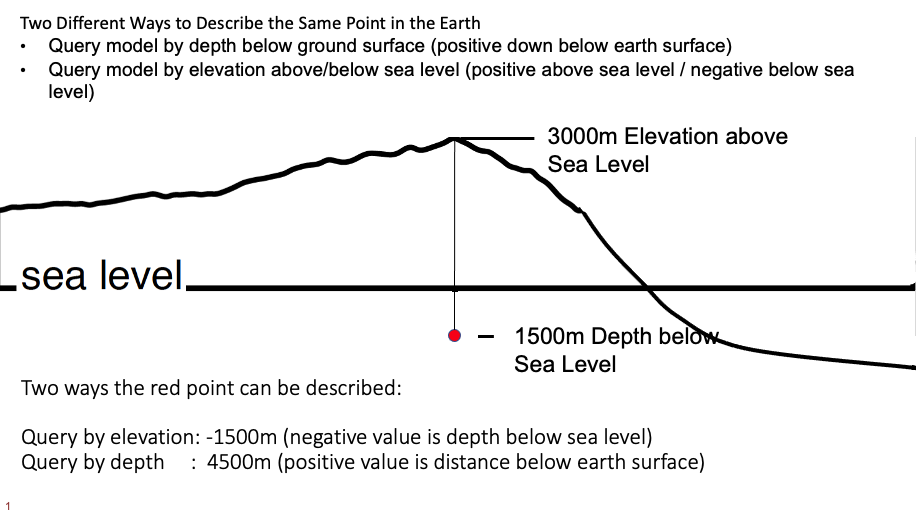
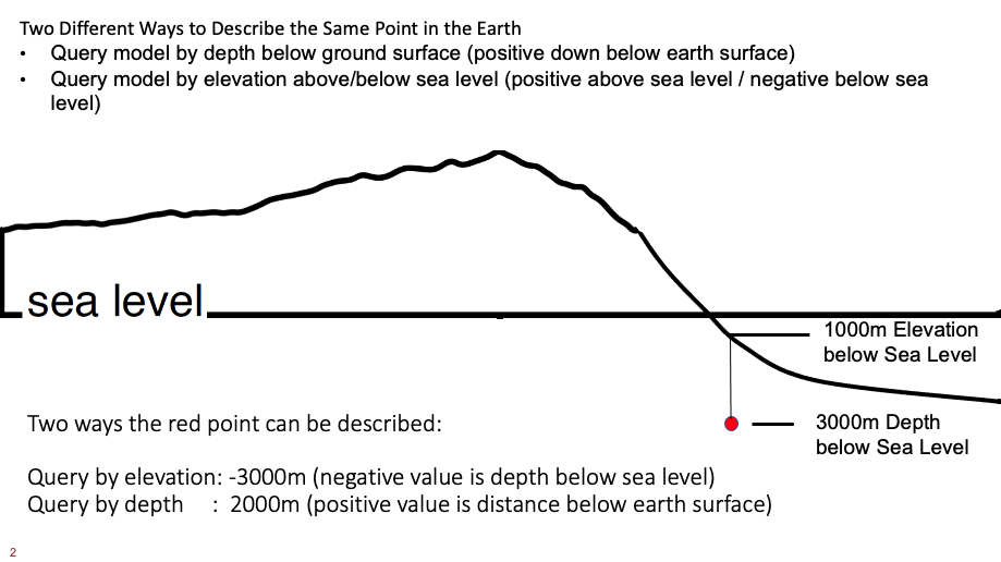
There are alternative ways to define a specific point in the earth. Assuming the point is below ground level, the same point can be described by lat long and depth below the solid earth surface, or as lat long and elevation above or below sea level.
The basic ucvm_query command support either mode. The query by depth below earth surface is the default. The basic ucvm_query gives user the option of query by depth (this is the default: -c gd) and query by elevation (-c ge).
These two queries are equivalent. Both are query by depth, and will retrieve earth properties at 100m depth:
- ucvm_query -f /usr/local/opt/ucvm/conf/ucvm.conf -m cvmh -l 33.84007,-117.95683,100.0
- ucvm_query -f /usr/local/opt/ucvm/conf/ucvm.conf -m cvmh -c gd -l 33.84007,-117.95683,1000.0
[ucvm@c9392335cfb4 target]$ ucvm_query -f /app/ucvm/conf/ucvm.conf -m cvmh -l 33.84007,-117.95683,100.0
Using Geo Depth coordinates as default mode.
 -117.9568    33.8401    100.000     34.438    293.500       cvmh   1361.703    120.690   1541.811       none      0.000      0.000      0.000      crust   1361.703    120.690   1541.811
ucvm_query prints the results to sdtout in a column oriented format. Abbreviations are like this:
output format is:
   0   1  2  3    4     5       6     7     8     9   10      11    12       13     14      15     16
  lon lat Z surf vs30 crustal cr_vp cr_vs cr_rho gtl gtl_vp gtl_vs gtl_rho cmb_algo cmb_vp cmb_vs cmb_rho
Based on the UCVM digital elevation model, we have determined this point has an elevation of xxx meters above sea level. To query the same point by elevation, we must determine the elevation of the query point. To determine the elevation of this point, we need to subtract the elevation from the depth value. Positive elevations are above sea level. Negative elevations are below sea level.
- (Elev at Lat/Lon) - (Query Depth below earth surface) = query elevation
We can determine the elevation of a point within UCVM's defined region by running a query at any depth. For example, if we query the above point by depth, we can obtain the elevation for the point from the "surf" column (identified as column 3 above) in the returned parameters, in this case 34.438m elevation.
[ucvm@c9392335cfb4 target]$ ucvm_query -f /app/ucvm/conf/ucvm.conf -m cvmh -l 33.84007,-117.95683,100.0
Using Geo Depth coordinates as default mode.
 -117.9568    33.8401    100.000     34.438    293.500       cvmh   1361.703    120.690   1541.811       none      0.000      0.000      0.000      crust   1361.703    120.690   1541.8110
Then we input this elevation into our formula to determine the query value used in query by elevation:
- 34.438 - 100.0 = -65.562
Then we define our ucvm_query, and add the -c ge command line parameter to indicate this is a query by elevation. This defines the same point in the earth in an alternative form, as elevation above or below sea level.
- ucvm_query -f /usr/local/opt/ucvm/conf/ucvm.conf -m cvmh -c ge -l 33.84007,-117.95683,-65.562
Since these three expressions represent the same point in the earth, they return the same results:
[ucvm@c9392335cfb4 target]$ ucvm_query -f /app/ucvm/conf/ucvm.conf -m cvmh -l 33.84007,-117.95683,100.0
Using Geo Depth coordinates as default mode.
 -117.9568    33.8401    100.000     34.438    293.500       cvmh   1361.703    120.690   1541.811       none      0.000      0.000      0.000      crust   1361.703    120.690   1541.811

[ucvm@c9392335cfb4 target]$ ucvm_query -f /app/ucvm/conf/ucvm.conf -m cvmh -c gd -l 33.84007,-117.95683,100.0
Using Geo Depth coordinates as z mode.
 -117.9568    33.8401    100.000     34.438    293.500       cvmh   1361.703    120.690   1541.811       none      0.000      0.000      0.000      crust   1361.703    120.690   1541.811

[ucvm@c9392335cfb4 target]$ ucvm_query -f /app/ucvm/conf/ucvm.conf -m cvmh -c ge -l 33.84007,-117.95683,-65.562
Using Geo Elevation coordinates as z mode.
 -117.9568    33.8401    -65.562     34.438    293.500       cvmh   1361.703    120.690   1541.811       none      0.000      0.000      0.000      crust   1361.703    120.690   1541.811
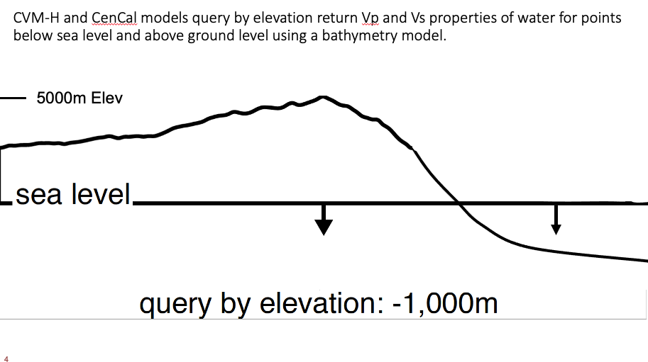
Query by depth, the user specifies a numeric value (in meters) at or below the surface. A depth of 0 is at the surface, a depth of 100 is interpreted at 100m below the surface. So depths are nearly always positive numbers.
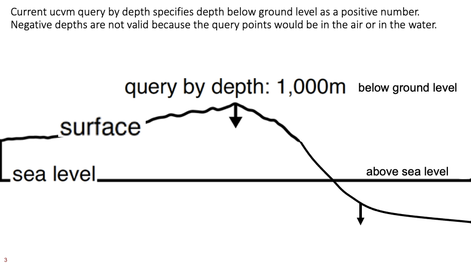
Query by elevation, the user specifies a numerical value (in meters) of elevation above or below sea level. An elevation of 0 is sea level. an elevation of 250 is an elevation of 250 meters above sea level. An elevation of -100 is 100 meters below sea level.
Please note that the user can query for elevations above the surface of the earth, which is "in the air". Also query by elevation in the ocean, above the ocean floor, will typically return Vs=0 indicating the point is in the water.


To support query by elevation, UCVM contains a digital elevation model for California. The elevation of a given point is returned in column 4 of the return parameters. User can query a model, using any elevation or depth, and UCVM return the elevation of that point in column 4. The user use this information to determine whether the elevation is at the point, and then can query at that elevation to get material properties at the surface for that point.


