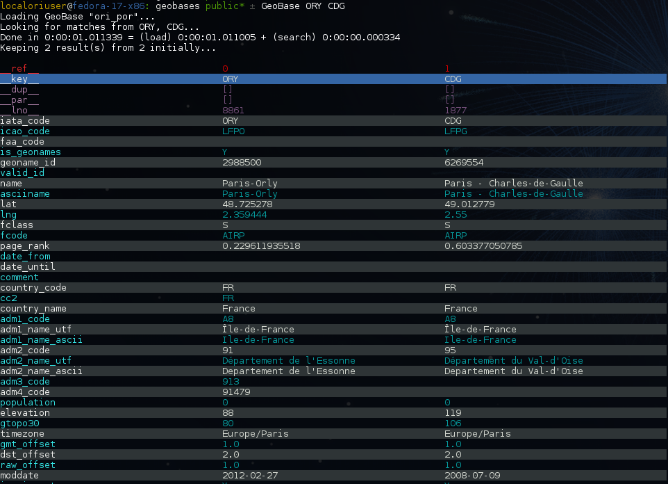
-
Notifications
You must be signed in to change notification settings - Fork 41
Command line examples
Installation of the package will also deploy a standalone script named
GeoBase:
$ GeoBase ORY CDG              # query on the keys ORY and CDG
$ GeoBase --closest CDG        # closest from CDG
$ GeoBase --near LIG           # near LIG
$ GeoBase --fuzzy marseille    # fuzzy search on 'marseille'
$ GeoBase --admin              # to administrate the data sources
$ GeoBase --help               # your best friend
In the previous picture, you have an overview of the command line verbose display. Three displays are available for the command line tool:
- the verbose display
- the csv display with
--quiet - the map display with
--map - the graph display with
--graph
With the verbose display, entries are displayed on each column, and the
available fields on each line. Fields starting with __ like
__field__ are special. This means they were added during data loading:
-
__key__is the field containing the id of the entry. Ids are defined with a list of fields in the configuration file. -
__dup__is the field containing a list of duplicated keys. Indeed there is mechanism handling duplicated keys by default, which creates new keys if the key already exists in theGeoBase. -
__par__is the field containing the parent key if the key is duplicated. -
__lno__is the field containing the line number during loading. -
__gar__is the field containing the data which was not loaded on the line (this can be because the line was not well formatted, or because there were missing headers).
More examples here, for example how to do a search on a field, like
admin_code (B8 is french riviera):
$ GeoBase -E adm1_code -e B8Same with csv output (customized with --show):
$ GeoBase -E adm1_code -e B8 --quiet --show __ref__ iata_code nameAdd a fuzzy search:
$ GeoBase -E adm1_code -e B8 --fuzzy sur merAll heliports under 200 km from Paris:
$ GeoBase --near PAR -N 200 -E location_type@raw -e 'H'50 train stations closest to a specific geocode:
$ GeoBase -E location_type@raw -e R --closest '48.853, 2.348' -C 50Countries with non-empty postal code regex:
$ GeoBase -b countries -E postal_code_regex -e '' --reverse --quietMultiple search on continent and currency_name:
$ GeoBase -b countries -E continent/currency_name -e AF/Euro Reading data input on stdin:
$ echo -e 'ORY^Orly\nCDG^Charles' | GeoBaseDisplay on map:
$ GeoBase -b stations --mapMarker-less map for a specific GMT offset:
$ GeoBase -E gmt_offset -e 1.0 --map -M _ _ country_code __none__Display your data on a map:
$ cat coords.csv
p1,48.22,2.33
p2,49.33,2.24
$ cat coords.csv | GeoBase --map
Display your data on a graph:
$ cat edges.csv
A,B
A,C
D,A
$ cat edges.csv | GeoBase --graph
If you want to learn more about the possibilities, use the learning mode:
$ GeoBase --ask