Releases: albar965/littlenavmap
Version 2.6.14
Note: Early downloads contained the wrong version number in the CHANGELOG.txt. You can ignore this since everything else is correct.
This version contains bug fixes, small user interface improvements and support for the new IVAO interface which allows higher update rates.
Direct Download
► Windows - LittleNavmap-win-2.6.14.zip
► macOS - LittleNavmap-macOS-2.6.14.zip
► Linux (64 bit, based on Ubuntu 20.04) - LittleNavmap-linux-20.04-2.6.14.tar.gz
► Linux (64 bit, based on Ubuntu 18.04) - LittleNavmap-linux-18.04-2.6.14.tar.gz
Alternative Download Locations
► Dropbox
► Mega.nz
► OneDrive
Known Issues
Read the linked chapter below to minimize issues when loading flight plans into MSFS:
► User Manual - Microsoft Flight Simulator 2020 Airports and Navdata.
See user manual for general known problems:
► User Manual - Known Problems.
See user manual for limitations and issues around Microsoft Flight Simulator 2020:
► User Manual - Known Problems - Microsoft Flight Simulator 2020.
Important Notes
- MSFS: Avoid the scenery library mode
Do not use Navigraph Databaseif you have the Navigraph update for MSFS installed. You will see errors in procedures. Instead directly update the scenery database of Little Navmap using the Navigraph FMS Data Manager. - The manual is not updated for the webserver / web user interface changes. Scroll by clicking or tapping and zoom by using the mouse wheel or the two-finger pinch gesture.
- The table column order and width for the search results is reset to default for the tabs
Online ClientsandOnline Servers.
Changes from 2.6.13 to 2.6.14
Flight Plan
- Fixed issue where waypoints being part of a missed approach were removed when saving a flight plan. #728
- Now disabling
Add Alternatein map context menu for empty flight plan to avoid crash when selecting without plan. - Enabled information display on right click or double click in flight plan table for navaids which are part of a procedure. Menu item was wrongly disabled before. #727
- Fixed problem where flight plan could be internally corrupted after saving. This caused a wrong warning about invalid destination airports when exporting plans and other issues like disappearing flight plan legs.
- Fixed issue where Garmin Base Camp could not load GPX files. Added missing attributes and default namespace in XML according to specification.
- Now avoiding ICAO region when exporting MSFS flight plans since it is not reliable for airports and the sim garbles the flight plan when loading. Example: Direct EDMG to LHSK.
- Reworked resolving of departure parking, helipad or runway positions from flight plan. Now omitting positions which are too far away from saved position for all simulators now. Fixed issue where helipad starting position was not loaded correctly in some cases.
- Saving and loading departure type (runway, parking, helipad, etc.) to LNMPLN now.
- Reorganized and cleaned up text in tab
Fuel Report.
Logbook
- Now omitting flight plan when saving a logbook entry instead of saving an invalid plan with missing waypoints. This happens if no flight plan was set while flying. Note that you still might see an exception if you try to save a flight plan from older log entries from flights without a plan.
- Now ignoring invalid or missing flight plans when saving GPX files from logbook entry. Previously showed an exception
Invalid LNMPLN flight plan file ".". No waypoints found.. - Adjustments for flying user aircraft detection to avoid creating log entries for low passes. #693
Procedures
- Now correcting final procedure legs where last altitude restriction is wrongly below airport elevation. This can happen due to errors in scenery libraries or runway threshold elevation being below general airport elevation. Little Navmap refused to build the elevation profile if this happened. #711
- Fixed issue where a far away VOR was selected instead of a closer ILS with the same ident when resolving fixes for procedures. Example: LJMB SID PETO5D RWY 32 showed a 800 NM leg towards a remote VOR.
- Corrected display issue in flight plan table where DME terminated procedure legs showed the wrong navaid and the wrong distance. Example: EGPH I06 via TLA showed
D322O+5instead ofTLA+20.
User Interface
- Added
Toggle Flight Simulator Connectionfunction with keyboard shortcutCtrl+Shift+Ain tools menu. This allows to quickly connect to the simulator. - Added previously missing keyboard shortcuts for functions
View->Show Aircraft(Ctrl+Alt+B) andView->Show Aircraft Trail(Ctrl+Alt+T). - Added keyboard shortcuts for map themes:
Ctrl+Alt+1toCtrl+Alt+6for default themes. - Fixed issue where coordinates for online aircraft map link were not updated in information panel. Clicking on the link
Mapshowed the wrong aircraft position as a result. #722 - VOR now shows
Calibrated declinationandMagnetic declinationin information window where the latter one is the environment value. - Added flown distance and takeoff time to progress tab. This is also available without flight plan.
Scenery Library
- Fixed issue where empty folders like
OneStorein the wrong place confused detection of MSFS. Now also checking for file.../fs-base/layout.jsonin required path. - Now logging empty, invalid or inaccessible XML and JSON files while scanning for MSFS or P3D scenery instead of throwing an exception. #720
- Now computing ARINC approach id (e.g.
I27C) for all approaches from FSX, P3D and MSFS to allow better procedure detection when loading flight plans across different simulator databases.
Other
- Added support for IVAO JSON 2 format in whazzup parser. Removed unneeded attributes for online airspaces and clients. Resetting online client, center and server search result table layout for database schema changes. Update rate is now 15 seconds for IVAO instead of two minutes. #722
- Several updates to the internal webserver / web user interface by u-an-i.
- X-Plane and Little Xpconnect: Now using more datarefs from flightmodel which are not affected by failures. #693
- Updated Qt libraries to 5.12.11.
See the included CHANGELOG.txt file or here online for a complete list across all versions.
All files are checked by VirusTotal.
Version 2.6.13
This version contains mostly bug fixes, adaption to MSFS scenery library changes, support for the new X-Plane TCAS scheme and a reworked web user interface.
Version 2.6.12.beta was an unofficial beta release.
Direct Download
► Windows - LittleNavmap-win-2.6.13.zip
► macOS - LittleNavmap-macOS-2.6.13.zip
► Linux (64 bit, based on Ubuntu 20.04) - LittleNavmap-linux-20.04-2.6.13.tar.gz
► Linux (64 bit, based on Ubuntu 18.04) - LittleNavmap-linux-18.04-2.6.13.tar.gz
► Linux (64 bit, based on Ubuntu 16.04) - LittleNavmap-linux-16.04-2.6.13.tar.gz
Alternative Download Locations
► Dropbox
► Mega.nz
► OneDrive
Known Issues
Read the linked chapter below to minimize issues when loading flight plans into MSFS:\
► User Manual - Microsoft Flight Simulator 2020 Airports and Navdata.
See user manual for general known problems:\
► User Manual - Known Problems.
See user manual for limitations and issues around Microsoft Flight Simulator 2020:\
► User Manual - Known Problems - Microsoft Flight Simulator 2020.
Important Notes
- You have to update/reinstall Little Navconnect and Little Xpconnect if you use these since the data protocol has changed. This version is compatible with Little Navconnect 2.6.11 and Little Xpconnect 1.0.24 or newer.
- Aircraft label settings are reset back to default. Adjust these in the options dialog on page
Map Display 2. - All MSFS scenery library related changes need at least MSFS version 1.16.2 .
- MSFS users need to reload the scenery library to new features like SID and STAR.
- Do not use the scenery library mode
Do not use Navigraph Databaseif you have the Navigraph udpate installed. You will see errors in procedures. Instead update the scenery database of Little Navmap using the Navigraph FMS Data Manager.
Changes from 2.6.11 to 2.6.13
Flight Plans
- Corrected loading and saving of GPX tracks. Now also saving timestamps and considering disconnected trail segments. A flight where the aircraft was moved or warped during flight results in a straight line connecting the two segments. Changing aircraft, restarting the simulator or Little Navmap results in disconnected trail segments.
- Fixed issue causing error messages on flight plan elevation profile calculation if destination airport is below sea level and an approach procedure is used.
- Flight cruise altitude was set wrongly after calculating route with metric altitude units.
- Now omitting visual reporting points (like
VP123) and other obscure numbered waypoints from route calculation. Also ignoring half degree points likeH5711in north atlantic now. Simplified and optimized loading of routing network. - Fixed issue where a flight plan calculation resulted in not optimal routes. This happened when a nearby navaid connected to the airway system could not be found.
Flight Plan Export
- Enabled departure parking position for MSFS flight plan export and import. Enabled check for parking position for MSFS export which shows a warning if starting on a runway. You can also set a fuel pad as starting position but note that runways and helipads as starting positions will be ignored by MSFS.
- More relaxed user waypoint naming conventions for MSFS. Now allowing more special characters.
- Corrected Aerosoft CRJ flight plan export as far as possible. Now exporting a list of waypoints instead of airway routes for MSFS CRJ to minimize issues when loading plan in aircraft. Adapted changed keywords in
.flpfile and compressing airway segments now. #632 - Added export of modified PLN format for Integrated Simavionics / ISG devices and gauges.
- Export option for MSFS PMS50 GTN750 Garmin added. This export saves the flight plan using a fixed filename
fpl.pln. - Now always adding procedure entry and exit waypoints for flight plan export formats not supporting procedures like FSX/P3D PLN. User can an additional waypoint in the simulator if needed.
- Corrected default flight plan pattern to use departure and destination ident if flight plan pattern is empty. Used departure airport ident wrongly before.
- Changes to allow updates for new export formats.
- Now clearing invalid procedures (red error message below flight plan table) before saving LNMPLN. Reloading a saved LNMPLN clears any error messages now.
Procedures and Scenery Library
- Now fully recognizing SID and STAR from MSFS scenery library. Many thanks to icykoneko for implementing this. #649
- Adapted loading of approach procedures and some airport structures to new MSFS changes since 1.16.2. This fixes the issue of empty and not selectable approaches in the procedure tab.
- Constant turn radius legs in procedures are now correctly depicted for MSFS.
- Fixed issue where some navaids did not get airport ident assigned if in different BGL file.
- Other improvements for procedure drawing.
- Added speed limit for MSFS procedure legs.
- Now checking all MSFS procedures before saving in the database. A warning will be logged and the procedure will be omitted if not valid.
- Now omitting closed dummy airport structures having no runways and no start positions which are used by MSFS as POIs.
- Fixed issue where an error was shown when loading
Library.xmlfiles from add-on aircraft. Library.xmlfiles are now considered when excluding folders from loading.- Removed exception for invalid files in X-Plane CIFP path. Now simply writing a warning to the log file.
Map
- Fixed issue where tooltips and click regions for route preview were wrongly active when showing more than on logbook entry highlighted.
- Added new airspace types MCTR, TRSA and GCA where GCAis for unknown and general types. #607
- Function
Center map on aircraft and next flight plan waypointnow uses defined box for aircraft and waypoint to avoid aircraft or next waypoint leaving screen space. More improvements to aircraft centering to avoid permanent updates or hanging view. - Corrected flight plan editing on map which could cause various issues if editing near a missed approach which is hidden on the map.
- Removed wrongly drawn procedure point underlay (like overfly indication) from intercept point for legs.
- Now updating online centers (transceivers) in VATSIM network every five minutes. Fixes issue where user had to restart LNM to update VATSIM centers.
Logbook
- Logbook entry now uses a separate aircraft trail which does not include previously flown segments from other flights.
- Corrected storing of local real time in logbook. Now uses a time format with timezone (not shown in logbook search result table).
- Avoiding crash if previously created logbook entry cannot be found on landing.
User Interface and General
-
Completely reworked web user interface. Now with mouse wheel zoom, a mode to follow the user aircraft and more. Big thanks to u-an-i for implementing this!
-
Now using new X-Plane TCAS AI and traffic scheme based on
sim/cockpit2/tcas/targetsdatarefs. Note that X-Plane provides only limited information about AI or multiplayer aircraft. Only transponder code, position, groundspeed, vertical speed and heading are available. #525 -
Fetching transponder code for all simulators now.
-
Added transponder code to user and AI aircraft. Now showing in tooltips, information and map.
-
Added transponder code option to aircraft labels. Note that aircraft label settings are now reset back to default.
-
Added properties to transferred simulator aircraft data to avoid future incompatibilities when adding new values.
-
Increased data version to 11 to force incompatibility. This requires to update/install Little Navconnect and Little Xpconnect as well.
-
Added links in flight plan table header to quickly get information and jump to departure, departure parking and destination on map.
-
Added clickable airport link to procedure search header to get information and jump to airport on the map.
-
Corrected issue where airport files were not found in related documents folder when using translated file and folder names. Adapted all translations to this change.
-
Added new userpoint icons based on Bushtalk Radio categories.
-
Little Xpconnect: Offloaded loading of aircraft files and scanning for keys to separate thread to avoid blocking main thread on startup. This could have caused stutters when starting X-Plane.
-
Chinese translation revised. Thanks to Tong Hui and yudongx for their effort.
-
Small updates to user manual regarding MSFS limitations.
Version 2.6.11
Direct Download
► Windows - LittleNavmap-win-2.6.11.zip
► macOS - LittleNavmap-macOS-2.6.11.zip
► Linux (64 bit, based on Ubuntu 20.04) - LittleNavmap-linux-20.04-2.6.11.tar.gz
► Linux (64 bit, based on Ubuntu 16.04) - LittleNavmap-linux-16.04-2.6.11.tar.gz
Alternative Download Locations
► Dropbox
► Mega.nz
► OneDrive
Known Issues
Read the linked chapter below to minimize issues when loading flight plans into MSFS:
► User Manual - Microsoft Flight Simulator 2020 Airports and Navdata.
See user manual for general known problems:
► User Manual - Known Problems.
See user manual for limitations and issues around Microsoft Flight Simulator 2020:
► User Manual - Known Problems - Microsoft Flight Simulator 2020.
Changes from 2.6.10 to 2.6.11
Weather
- Fixed
Error downloading or reading wind dataissue. Adapted URL for winds aloft download to NOAA changes and addedatmosas directory. #623 - Now suppressing wind and other downloads with log warning message if URLs are empty. #623
- New decompression methods to speed up weather and track downloads.
- Now showing airport weather symbols on higher zoom levels. Avoiding simple line on wind barb which can be confused with low wind.
Flight Plans
- Corrected approach identifier in FLP flight plan export and loading for Aerosoft aircraft. Now using ARINC identifier for approaches and ignoring transitions of type
VECTOR. Adapted changed keywords in file for CRJ. Problems still appear when loading flight plans into the aircraft. This will be fixed in one of the next updates. - Added extra entry for Aerosoft MSFS CRJ in multi export to avoid loading issues because of a too long file name.
- Added patch by Slawek Mikula to support loading of Aviamaps flight plans. #616
- Exporting online network flight plan files from menu now correctly remembers last used folder for each format.
Other
- Adjustments to drawing. ILS, online aircraft and AI aircraft are now shown at higher zoom levels.
- Added support for new VATSIM JSON version 3 data feed. Better update rate for online networks is now one minute for VATSIM and PilotEdge and two minutes for IVAO. Allowing centers and clients (VATSIM prefile) without coordinates now throughout program. Keep in mind that the real center boundaries are not depicted yet. #606
- MSFS: Now ignoring invalid content types like
Unknownin MSFSmanifest.jsonfile which are often set wrongly by add-on developers. This kept add-on airports from showing up. - Fixed issue where userdata CSV backup files could not be loaded and had to be manually corrected before import.
- Updates for detection of military airports and name capitalization.
- More small user interface corrections.
See the included CHANGELOG.txt file or here online for a complete list across all versions.
All files are checked by VirusTotal.
Version 2.6.10
Direct Download
► Windows - LittleNavmap-win-2.6.10.zip
► macOS - LittleNavmap-macOS-2.6.10.zip
► Linux (64 bit, based on Ubuntu 20.04) - LittleNavmap-linux-20.04-2.6.10.tar.gz
► Linux (64 bit, based on Ubuntu 16.04) - LittleNavmap-linux-16.04-2.6.10.tar.gz
Alternative Download Locations
► Dropbox
► Mega.nz
► OneDrive
Known Issues
Read the linked chapter below to minimize issues when loading flight plans into MSFS:
► User Manual - Microsoft Flight Simulator 2020 Airports and Navdata.
See user manual for general known problems:
► User Manual - Known Problems.
See user manual for limitations and issues around Microsoft Flight Simulator 2020:
► User Manual - Known Problems - Microsoft Flight Simulator 2020.
Changes from 2.6.9 to 2.6.10
- Fixed crash that occurs when showing the dialog
The flight plan had no valid start positionon startup. This kept the user from starting Little Navmap. - Removed wrong warning dialog about start position when loading MSFS flight plans. MSFS cannot load start positions like gates from a flight plan file.
- Fixed missing time, fuel and altitude values for departure and destination legs in flight plan table.
- Corrected message in progress tab which gave the wrong impression that program is already connected when using a network connection.
- Fixed issue where minimum zoom was wrongly set in the elevation profile in some cases. As a result the user could not zoom in to the minimum of around 4 NM and was stuck at much higher levels.
- Changed keyboard shortcut for
Create Approachin context menus toAlt+Shift+Rto avoid overlap withCalculate Flight Plan. - Added new sub-menu
Track Sourcesin menuFlight Planwhich allows to enable or disable the different track systems to load. Note that AUSOTS is disabled per default since there are no flex tracks available for almost one year and the service is unreliable causing download errors. - More small user interface and map display improvements.
See the included CHANGELOG.txt file or here online for a complete list across all versions.
All files are checked by VirusTotal.
Version 2.6.9
►► This is a bugfix release which addresses an unrecoverable crash on startup when downloading tracks (Caught unknown exception in file ... line 85). ◄◄
Links
► Screenshots of 2.6 Features
► Little Navmap and Little Navconnect User Manuals for 2.6 Versions
Direct Download
► Windows - LittleNavmap-win-2.6.9.zip
► macOS - LittleNavmap-macOS-2.6.9.zip
► Linux (64 bit, based on Ubuntu 20.04) - LittleNavmap-linux-20.04-2.6.9.tar.gz
► Linux (64 bit, based on Ubuntu 16.04) - LittleNavmap-linux-16.04-2.6.9.tar.gz
Alternative Download Locations
► Dropbox
► Mega.nz
► OneDrive
Notes
Read the linked chapter below to minimize issues when loading flight plans into MSFS:
User Manual - Microsoft Flight Simulator 2020 Airports and Navdata.
Known Issues
See user manual for general known problems:
See user manual for limitations and issues around Microsoft Flight Simulator 2020:
User Manual - Known Problems - Microsoft Flight Simulator 2020.
Changes from 2.6.8 to 2.6.9
- Fixed unrecoverable error when downloading PACOTS tracks.
- Improved error handling for unreadable track information. Program now logs an error message
instead of crashing. - Fixed error when reading procedures with invalid or unknown approach types from FSX, P3D and MSFS.
Now logging error instead.
See the included CHANGELOG.txt file or here online for a complete list across all versions.
All files are checked by VirusTotal.
Version 2.6.8
Links
► Screenshots of 2.6 Features
► Little Navmap and Little Navconnect User Manuals for 2.6 Versions
Direct Download
► Windows - LittleNavmap-win-2.6.8.zip
► macOS - LittleNavmap-macOS-2.6.8.zip
► Linux (64 bit, based on Ubuntu 20.04) - LittleNavmap-linux-20.04-2.6.8.tar.gz
► Linux (64 bit, based on Ubuntu 16.04) - LittleNavmap-linux-16.04-2.6.8.tar.gz
Alternative Download Locations
► Dropbox
► Mega.nz
► OneDrive
Notes
Read the linked chapter below to minimize issues when loading flight plans into MSFS:
User Manual - Microsoft Flight Simulator 2020 Airports and Navdata.
Known Issues
See user manual for general known problems:
User Manual - Known Problems.
See user manual for limitations and issues around Microsoft Flight Simulator 2020:
User Manual - Known Problems - Microsoft Flight Simulator 2020.
Changes from 2.6.7 to 2.6.8
Help and Manuals
- Revised German user manual for spelling and grammar errors.
- Small additions and corrections to English manual.
General
- Reverted change that was needed for work around a MSFS crash which occured when connecting. Now fetching destination and departure for AI aircraft again.
- Fixed unrecoverable crash on startup which can occur with Mercator projection zoomed far out.
- Resolved crashes when showing information for VOR and NDB having no type like
HighorTerminal. - Added error handling for missing layout file on startup if
Load window layout from last used fileinOptionson pageStartup and Updatesis checked. Removing or renaming the layout file resulted in an unrecoverable crash on startup. - Fixed procedure display issues for turn bow after circular legs. Example: LGSR VOR-B transition BINKI.
- Fixed issue where weather from FSX and P3D was not transferred across networked connections.
- Logbook details (route preview and trail) on the map are now only shown if one entry is selected in the logbook search result table. Selecting more than one entry shows only the direct connection lines if enabled. This fixes performance issues when selecting many logbook entries.
- Added warning dialog when user switches to offline mode.
- Fixed issues with disappearing flight plan and measurement lines. Lines might still disappear near the poles for long flight plan legs depending on zoom factor.
- Navaid resolution when loading flight plans or switching scenery databases is now more tolerant for wrong ICAO regions. Navaids were marked red with an error in the flight plan table before if the region did not match.
- Fixed issue resulting in degraded drawing performance for airport diagrams. This was most visible on large airports.
- Various drawing and user interface corrections.
Flight Plan
- Fixed issue where waypoints inserted for procedure endpoints received wrong altitude when saving or exporting flight plans right after calculation. This caused error messages when loading the resulting LNMPLN files. GitHub issue #608.
- Now extracting ICAO airport idents for waypoints, NDB and VOR for MSFS export. PLN element
ICAOAirportwas missing before and caused problems when loading flight plans in MSFS. GitHub issue #614. - Split up export options for JARDesign and Rotate aircraft to allow export for both separately.
- Corrections to X-Plane FMS export. Using keywords
DEPandDESnow instead of truncating ident. This allows to reload the FMS file in Little Navmap. - Fixed a regression where circle-to-land approaches could not be loaded by X-Plane due to missing destination runway in FMS export.
- Fixed flight plan export for FSX and MSFS which used the wrong coordinates for destination element
DestinationLLAin flight plan. This confused third party programs which relied on this value. - Corrected wrong departure position for saved LNMPLN and FSX/P3D PLN flight plans. Now uses position from parking, helipad or runway/start for PLN
DepartureLLAand LNMPLNStartelement. GitHub issue #613. - Fixed issue where LNMPLN flight plan procedures were replaced with waypoints inadvertently if enabled in export options menu. This happened when saving LNMPLN plans with multiexport.
- Removed extra space to fix flight plan export for iFly (
.FLTPLAN). - Other small corrections for flight plan export.
See the included CHANGELOG.txt file or here online for a complete list across all versions.
All files are checked by VirusTotal.
Version 2.6.7
Links
► Screenshots of 2.6 Features
► Little Navmap and Little Navconnect User Manuals for 2.6 Versions
Direct Download
► Windows - LittleNavmap-win-2.6.7.zip
► macOS - LittleNavmap-macOS-2.6.7.zip
► Linux (64 bit, based on Ubuntu 20.04) - LittleNavmap-linux-20.04-2.6.7.tar.gz
► Linux (64 bit, based on Ubuntu 16.04) - LittleNavmap-linux-16.04-2.6.7.tar.gz
Alternative Download Locations
► Dropbox
► Mega.nz
► OneDrive
Known Issues
- No SID and STAR yet from MSFS scenery library. This will come with a future update.
- MSFS multiplayer traffic is not shown in Little Navmap.
See also User Manual - Known Problems for more.
Changes from 2.6.6 to 2.6.7
Help
- Updated German online and included PDF manual as well as legend for changes in version 2.6. Little Navmap - Benutzerhandbuch.
- Updated German program translation.
- Corrections to English online and PDF manual as well as map legend.
MSFS
- Added workaround for the simulator crashes that were introduced with the MSFS 1.12.13.0 update. This was possible due to a hint in the official forum. The workaround disables the display of departure and destination for AI.
User Interface
- Corrected issue where status bar was hidden on first start or after first installation. Now forcing status bar to be visible again when updating from any older version to 2.6.7.
- Flight plan calculation window changed to appear near cursor on first show to avoid random placement off-screen.
- Added recovery if main window gets off screen after changing monitors. Puts window back on top left of main screen if it is not visible.
- Fix for Windows removing file extensions when these are hidden in Windows Explorer. This prevented saving of map images.
- Winds aloft now scanning for the latest dataset to avoid outdated reports. Note that reports might still be outdated at times which happens if no newer one is available.
Map and Elevation Profile
- Fixed cut off altitude labels on the elevation profile left area.
- Measurement lines now use the declination at the end to calculate magnetic great circle course at end of line. The start course is still calculated based on start declination or attached navaid declination.
- Fixed issue where wrong
Too many objectsmessage was shown and map performance degraded with tracks enabled. - Fixed several issues when centering route or flight plan legs with very long flight plans.
- Fixed issues when painting aircraft trail around the anti-meridian.
- Now painting full aircraft trail even when jumping long distances.
- Adjustments and optimizations for taxiway label drawing. Map shows more labels now.
- Markers are now fetched from the simulator database in default scenery mode just like the ILS. Previously markers from add-on sceneries were not visible.
- Fixed issues where marker tooltips appeared after hiding ILS and markers.
- Fixed zooming functions with keyboard input in map where normal zooming was not possible on US and other keyboard layouts.
- Disabled home key which zoomed the map all way out when hit accidentally.
- Fixed crash when disabling all labels for measurement lines. This caused the program to crash on startup which was hard to recover.
Procedures
- Fixed issue where intercept procedure legs were not calculated correctly. Examples: LGKO SID 32 KOPA3A and LILJ SID DOL1W.
- Small improvements in procedure drawing for turn legs to avoid too large course discrepancies between label and line caused by drawing turn.
- Corrected drawing for several procedure leg types and labels in elevation profile.
Scenery Library
- Now also including MSFS scenery with content type
COREwhich kept Little Navmap from loading some add-on airports. - Now skipping file
maintenance.bglfrom Navigraph update in MSFS scenery library which caused warnings when loading. - Airport names now loaded from base scenery with Navigraph update in MSFS. Were missing previously.
- Now omitting scenery library entries which are marked with
active="false"inContent.xml. This lets Little Navmap to recognize changes made by scenery management tools now.
Flight Plan and Export
- Now always adapting departure and destination airport names to the names taken from the selected scenery library. This also affects the proposed files names when saving or exporting flight plans. Behavior before was confusing since it kept an airport name from a previously used simulator scenery database.
- Flight plan calculation now correctly omits waypoints which are part of a procedure. These should be avoided for en-route navigation and are excluded now from calculation except for airway waypoints.
- Folder names are now remembered correctly for MSFS and FSX/P3D manual flight plan export instead of using an arbitrary place depending on scenery library selection.
- Now setting voice type to
Fullas a default for vPilot export since other values produce error messages. - Applied workaround for XML files with wrong encoding in header. This helps to read wrongly decoded ForeFlight flight plans which are saved in UTF-16 while having a UTF-8 indication in the file header.
- Fix for GPX export to allow saving of files and trails without flight plan. An empty flight plan does not disable the export menu item now and allows to save only the trail as GPX.
- Fixed issue with X-Plane FMS plans where long airport idents like
XRP0001cannot be loaded by the simulator. Idents are now truncated to six characters. - Exported FLP flight plans
Aerosoft Airbus and othersandAerosoft CRJnow get a suffix01.flpto avoid import problems in the aircraft. Note that the number is static and is not counted up.
See the included CHANGELOG.txt file or here online for a complete list across all versions.
All files are checked by VirusTotal.
Version 2.6.6
Links
► Screenshots of new 2.6 Features
► Little Navmap and Little Navconnect Manuals for 2.6 Versions
Direct Download
► Windows - LittleNavmap-win-2.6.6.zip
► macOS - LittleNavmap-macOS-2.6.6.zip
► Linux (64 bit, based on Ubuntu 20.04) - LittleNavmap-linux-20.04-2.6.6.tar.gz
► Linux (64 bit, based on Ubuntu 16.04) - LittleNavmap-linux-16.04-2.6.6.tar.gz
Alternative Download Locations
► Dropbox
► Mega.nz
► OneDrive
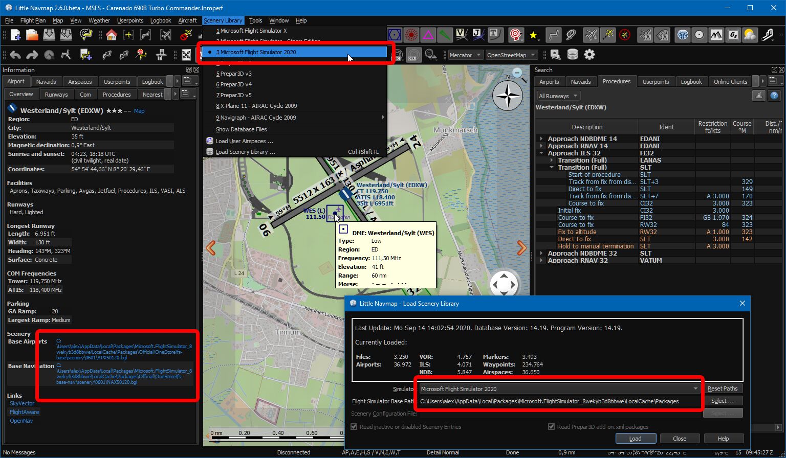
Little Navmap using style Night showing Microsoft Flight Simulator 2020 functions. Airport, taxiways, apron, parking spots, approaches and navaids are visible.
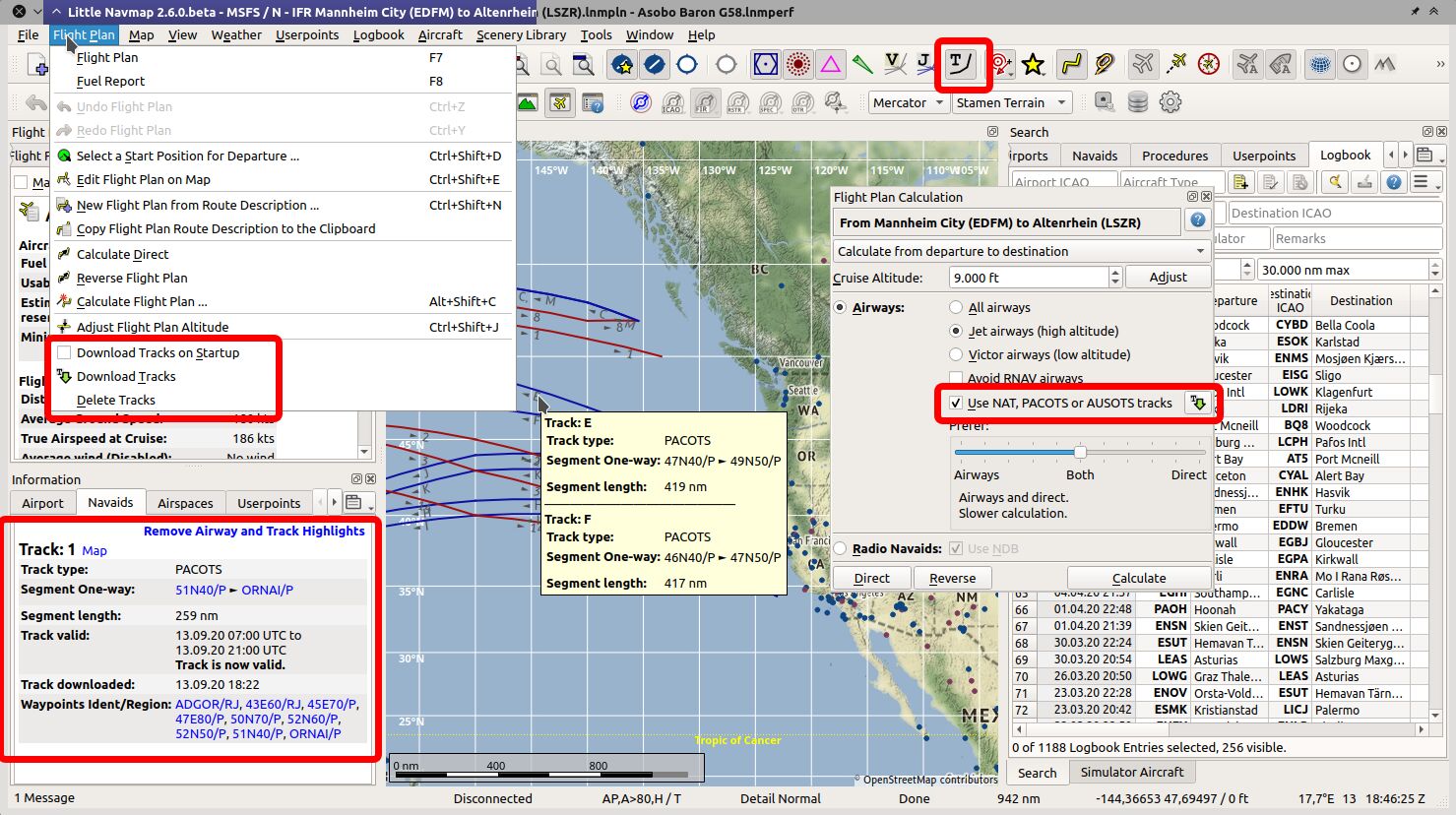
PACOTS oceanic tracks visible on map, tooltip and information view.
New flight plan calculation window opened.
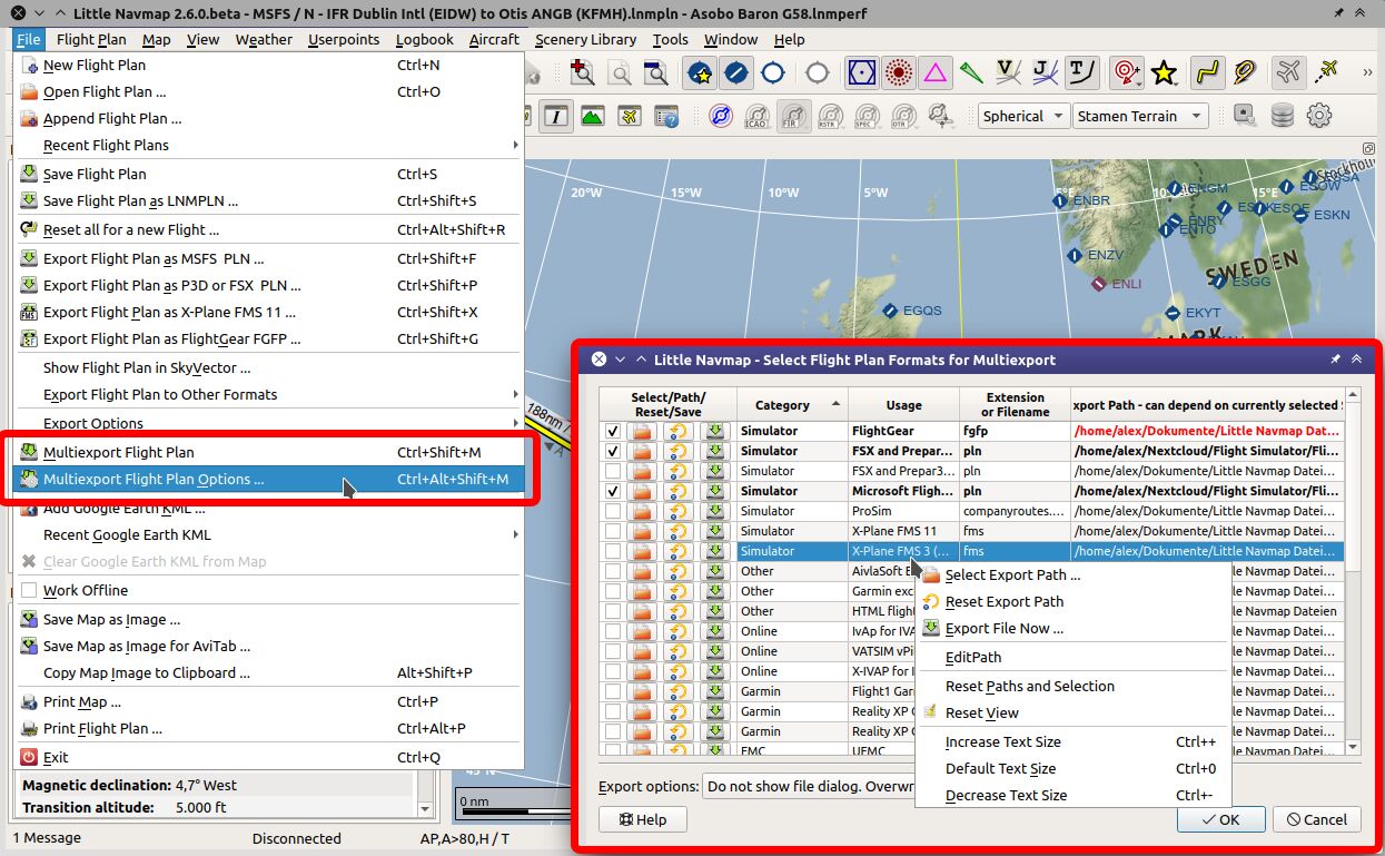
Multi-export configuration window open with context menu.
Important
- The data exchange protocol has changed. You have to update Little Navconnect (if using
remote/network connections) and Little Xpconnect (if using X-Plane) too. Both are included in the Little Navmap download package. - Reload the scenery library database to see fixes and improvements.
- Little Navmap asks to create a recommended folder structure for files on first start after updating to 2.6 versions.
Let the program create the paths if you like to use them and move your files accordingly.
Note that this is purely optional. All Files of Little Navmap can be stored in any place.
Known Issues
See here: User Manual - Known Problems.
Notable Changes from Release 2.4.5 to 2.6.6
User Manuals and Help
- All help buttons and links are functional now in the program.
- English online manual is now complete and vailable for download in PDF, EPUB and MOBI format:\
Little Navmap and Little Navconnect Manuals.
New Chapters
- Flight Plan Route Calculation
- Flight Plan Multiexport
- Tracks
- Edit Flight Plan Position
- Edit Flight Plan Remarks
- Window Layout
- Network Setup
- Start
- Directories
Updated Chapters
- Flight Plan Formats
- Options
- Installation
- Menus and Toolbars
- Introduction
- Map Display
- Legend
- Elevation Profile
- Logbook
- Connecting to a Flight Simulator
- Tutorial - Building a VFR Flight Plan
- Tutorial - Building an IFR Flight Plan with Approach Procedures
- Tutorial - Creating an Aircraft Performance Profile
Program Changes
- Microsoft Flight Simulator 2020 support. Little Navmap detects all known MSFS installation paths, can read the scenery library, follows user aircraft and can save/load flight plans also with procedures. All star airports in MSFS get a five star rating in Little Navmap. See known issues above for limitations.
- Oceanic tracks: NAT, PACOTS and AUSOTS. Visible on map and can be used in flight planning as well as for automatic plan calculation. See
Flight Plan->Download Tracks. - Multi-export: Export more than one flight plan format at once with just one click. Formats and paths are configurable. See
File->Multi Export Flight Plan Options. - Improvements to logbook: A log entry now gets track and flight plan attached which can be saved or shown in preview.
- Added total flight time numbers in logbook statistics dialog.
- Improved flight plan calculation. Can now calculate across regions which are void of airways. Can use oceanic tracks, avoid RNAV airways and more options.
Flight Plan->Calculate Flight Plan. - Little Navmap now uses its own flight plan format (extension
LNMPLN) which allows removing most of the confusing warning dialogs. Flight plan saving and loading logic has changed completely and is now more straigtforward. - User can add remarks or comments on flight plan and flight plan waypoints. See tab
Flight Plan RemarksinFlight Planningdock window. Right click on flight plan waypoint in plan table or map and selectEdit Flight Plan Position Remarks. - Auto renumbering all user flight plan positions (green rectangle) that match default name pattern prefixed with
WPlikeWP1,WP2orWP99now. Note that positions are already renumbered when loading a plan. - Program suggests to create a recommended folder structure on first startup. Click
Do not show this dialog againand pressCancelif you do not like this. - Added option to extract flight plan for selected range and save it into a new file. Select a range of flight plan legs not touching alternates or procedures. Then right click into the table and choose
Save selected Range as Flight Plan. This will not replace the current plan but add the saved file to the recent files list. - Better map context menu with sub-menus for easier selection of actions if more than one map object is below clicked position.
- Changed display functionality to force add-on airport display. Now keeping add-ons airports visible on map independent of zoom level if this option is selected in the toolbar or the menu
View->Airports->Force Show Add-on Airports. Add-on airports are now shown highlighted with a yellow ring per default. Add-on highlighting can be disabled in options dialog on pageMap Display. The colors can be adjusted in the configuration filelittle_navmap_mapstyle.ini. - Now always drawing approach procedure related ILS and airport diagram from flight plan even if these features are disabled in map. Allows to hide all map features and show only the important flight plan related navaids.
- Changed display when increasing or decreasing detail level on map. Now also scaling icons, texts and other map object features. Detail level can now be used to show airport diagram earlier.
- Replaced title bar information for mouse hover in elevation profile with tooltip window showing more information.
- User can now select font for user interface and map display. Options dialog on pages
User InterfaceandMap.
See b612-font for an open source font used in aviation. - Free user interface language selection (if translation available). Change this in the dialog
Optionson pageUser Interface - Fullscreen mode maximizes map on one click or key press of
Shift+F11. SeeWindow->Fullscreen Map. - Save and load window layouts for dock windows. This also saves toolbar positions and the main window size. See menu
Window. Layouts are saved separately for both normal and fullscreen mode. Added option to restore window layout from last loaded file on startup. This is the file on top of theRecent Window Layoutsmenu. See options dialog on pageStartup. - Changed default window layout which is used after
Reset Window Layout to Defaultto one where dock windowsSearchandSimulator Aircraftare merged into a tabbed view. This avoids the frozen (not resizable) elevation profile window. Look for the tabsSearchand...
Version 2.4.5
Direct download: Windows - macOS - Linux (64 bit, based on Ubuntu 18.04) - Linux (64 bit, based on Ubuntu 16.04)
Alternative download locations: Dropbox - Mega.nz - OneDrive
P3D v5 #512
- Added P3D v5 for simulator detection.
- Adapted loading of BGL files to P3D v5 structure changes and added new records as well as new COM
and other types. - Enabled loading of add-on packages from
%USERPROFILE%\Documents\Prepar3D v5 Add-ons.
Fixed crashes and other errors
- Fixed crash to desktop when adding an approach after a list of user defined waypoints. #500
- Fixed error reporting in wind download and decoding. Program does not crash to desktop if wind
download has errors. #480 - Now limiting weather display to the 10 most important/biggest airports if connected via network
or SimConnect to P3D/FSX. This helps to minimize map stutters when scrolling or zooming. #497
Disable display of airport weather symbols if this still appears:- Menu
Weather->Airport Weather Source: Select anything butSimulator. - Or menu
View: DisableShow Airport Weather.
- Menu
- Fixed crash when entering an invalid ICAO in web interface for airport information. #491
- Fixed wrong handling of
Options/RenderOptsetting inlittle_navmap.ini. - Corrected encoding when exporting flightplan as HTML page.
User Interface
- Fixed spelling and typos in user interface.
- Small UI changes in connection dialog for more clarity.
- Added word wrap to avoid dialogs growing too large in user interface.
- Better display on mobile devices for webserver.
- Updated German legend.
Build for Developers
- Added option to include common "../build_options.pro" file with defines for qmake.
File is included automatically if it exists.
related from atools version 3.4.6
- Fixed error reporting in wind download and decoding. #480
- Added option to include common "../build_options.pro" file with defines for qmake.
- Chinese translation by John Liu.
Version 2.4.4
Direct download: Windows - macOS - Linux (64 bit, based on Ubuntu 18.04) - Linux (64 bit, based on Ubuntu 16.04)
Alternative download locations: Dropbox - Mega.nz - OneDrive
► Screenshots of new 2.4 Features
Update
- Added German translation package for the manual (LittleNavmap-manual-language-package-de-2.4.zip). Install this to get access to the updated German legend and online help (Little Navmap Handbuch). Includes the PDF manual.
Many thanks to Karl Wichelmann, Stephan Leukert and merspieler for the German translation of the user manual.
Notes
- Microsoft Visual C++ Redistributables are not needed.
- Reload the scenery library.
- Reinstall the Little Xpconnect X-Plane plugin to see bug fixes.
- Little Navmap resets the map theme back to OpenStreetMap to avoid wrong selection of the now unavailable OpenMapSurfer theme.
- Route description options are reset to defaults.
Known Issues
- Scrolling is stuttery when using airport weather symbols based on simulator data for FSX/Prepar3D. Switch off airport weather symbols to avoid this.
- The browser often does not jump to the right chapter the first time when opening online manuals. Got to the URL bar, do not change the URL and press return if this happens.
Notable Changes
- Winds aloft forecast for display and fuel planning.
- Wind gust factor in airport weather symbols.
- Alternate airports for flight plan and fuel planning.
- Complete rework of logbook. Separated from userpoints and improved functionality.
- Permanent aircraft performance collection. Results can be merged any time. Improvements to fuel planning.
- Accurate fuel and time prediction in aircraft progress tab based on aircraft performance.
- Internal webserver. Access map and flight plan from everywhere.
- ILS tooltip and information.
- User defined final approach for vertical guidance including VASI and ILS slope at any airport.
- Preferred runway by wind for airports in tooltip and information.
- Nearest navaids and airports around a selected airport.
- Display holdings on map like traffic patterns.
- Two new map navigation modes: Click to center and navigation areas for touchscreens.
- Map images can now be saved with an arbitrary size.
- Hide columns in flight plan table.
- Can highlight full airways from information window
Maplink like airspaces. - Improved airspace database. Added user airspaces. Assign online centers to airspace geometry.
- Movable and closable tabs. Tab menu button and context menu for tabs.
- Fixed all known procedure display issues.
- Display alternate fuel units and true course optionally.
- User features like range rings, holds and others can be hidden on the map.
- Error and warning messages in user interface have tooltip for more information now.
- Many user interface improvements and bug fixes for procedure display, METAR parsing and more.
Changes from Release 2.2.4 to 2.4.4
See CHANGELOG.txt in littlenavmap project for changes across all versions.
Manuals
- Only English offline PDF manual included. Manuals for French, Italian and German are still based on version 2.2. Updates will follow later. You can access all older manuals based on Little Navmap 2.2 versions and all work in progress here:
Little Navmap and Little Navconnect Manuals. - Sources for the manuals are committed to GitHub and can be found here on branch
release/2.4for translation.
Help - New Chapters
- Dock Windows
- Tabs
- Holding
- Image Export
- User Defined Approach
- Reset all for a new Flight
- Aircraft Performance Merge
- Logbook
- Winds aloft
- OpenAir Airspaces
- Web Server
- Tutorial - Creating an Aircraft Performance Profile
- Keyboard Shortcuts
Help - Updated Chapters
- Menus and Toolbars. Updated for new functions.
- Overview. Updated images and added image for help.
- Legend. Updated for new features.
- Flight Plan Tab. Wind and alternates.
- Flight Plan Route Description. Updated for alternates.
- Edit Aircraft Performance. Updated for wind and changed report.
- Aircraft Performance Collection. Permanent collection.
- Aircraft Performance. New performance features.
- Information Dock Window. Logbook, userpoint tabs and airport file links. Nearest and preferred runways.
- Options Dialog
- All Tutorials
User Interface Translation
- User interface translation is complete for the languages French, Italian, German and Brazilian Portuguese.
Many thanks to Patrick, Flavio, Valerio and Ricardo for their work. - Spanish and Dutch translations are not adapted and the program will show a mix of English and the local language.
User Interface
- User interface translation is complete for the languages French, Italian, German and Brazilian Portuguese.
Other translations (Spanish and Dutch) are not adapted and the program will show a mix of English and the local language.
Many thanks to Patrick, Flavio, Valerio and Ricardo for their work. - Tabs can now be closed and moved in information display, aircraft progress, flight plan and
search. #437 and #345- A drop down menu in a button at the right top corner and a context menu on the tab bar allow to
close, open and lock tabs. - Tab states and positions are saved between sessions.
- Tabs are opened and/or raised on demand on info click or menu selection.
- Reset window layout also resets tab layout and reopens all closed.
- A drop down menu in a button at the right top corner and a context menu on the tab bar allow to
- Now raising windows and/or tabs optionally on actions like e.g.
Set Destination. Also after
loading, importing or creating a new flight plan, aircraft performance file or others.
This should help to avoid confusion when creating new or modifying documents.
This behavior can be disabled inOptions->User Interface->Raise related windows .... - Moved map theme and projection into separate toolbar. This helps to avoid toolbar overflow on the
right for the map toolbar. - Added menu item to save all options and window layout. Menu
Tools->Save Options and State. #420 - Renamed dock window
Flight PlantoFlight Planningand tabAircraft Performanceto
Fuel Report. - Added
Reset all Settings and Restartfunction in tools menu which replaces the need to delete the settings
folder in case of issues. This will cre...