-
Notifications
You must be signed in to change notification settings - Fork 168
HiRISE
HiRISE 
The Mars Reconnaissance Orbiter Mission
Instrument Overview 
HiRISE has acquired more than 20,000 images of the martian surface in unprecedented detail.
HiRISE operates in visible wavelengths with a telescope that will produce images at resolutions never before possible in planetary exploration. These high resolution images will enable scientists to resolve 1-meter (about 3-foot) sized objects on Mars and to study the morphology (surface structure) in a much more comprehensive manner than ever before.
From an altitude of approximately 300 kilometers above Mars, HiRISE will return surface images comprised of pixels representing 30 centimeters of the martian surface.
These high-resolution images provide unprecedented views of layered materials, gullies, channels, and other science targets, as well as possible future landing sites.
A comparison between the resolution of a camera aboard
Mars Global Surveyor and the HiRISE camera on
Mars Reconnaissance Orbiter. Credit: NASA/JPL
Technical Details 
This telescopic camera has a primary mirror diameter of 50 centimeters and a field of view of 1.15°. At its focal plane, the instrument holds an array of 14 electronic detectors, each covered by a filter in one of three wavelength bands: 400 to 600 nanometers (blue-green), 550 to 850 nanometers (red), or 800 to 1000 nanometers (near-infrared). Ten red detectors are positioned in a line totaling 20,028 pixels across to cover the whole width of the field of view. Typical red images are 20,000 pixels wide by 40,000 lines high. Two each of the blue-green and near-infrared detectors lie across the central 20% of the field. Pixel size in images taken from an altitude of 300 kilometers will be 30 centimeters across, about a factor of two better than the highest-resolution down-track imaging possible from any earlier Mars orbiter and a factor of five better than any extended imaging to date. Generally, at least three pixels are needed to show the shape of a feature, so the smallest resolvable features in the images will be about a meter across for an object with reasonable contrast to its surroundings. The instrument uses a technology called time delay integration to accomplish a high signal-to-noise ratio for unprecedented image quality.
The Principal Investigator (lead scientist) for HiRISE is Alfred McEwen from the Lunar and Planetary Laboratory at the University of Arizona .
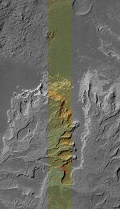
This image is one half (vertically) of a HiRISE observation
scaled down to approximately 1/50th of its original resolution.
It is of a small area inside Eberswalde crater in
Margaritifer Sinus. Taken on November 8, 2006, the image is a
composite of all 10 red detectors and the 2 blue-green detectors.
This is a full resolution sub-area of the image on the right
(indicated by the red outline). One pixel represents 25.6 cm
on the surface of Mars.
References & Related Resources 
HiRISE_Sample_Full_Resolution_Subarea.png View (564 KB) Ian Humphrey, 2016-05-31 02:51 PM
HiRISE_Sample_Observation.png View (403 KB) Ian Humphrey, 2016-05-31 02:51 PM
MRO_HiRISE.jpg View (105 KB) Ian Humphrey, 2016-05-31 02:52 PM
- Building
- Writing Tests
- Test Data
- Start Contributing
- Public Release Process
- Continuous Integration
- Updating Application Documentation
- Deprecating Functionality
- LTS Release Process and Support
- RFC1 - Documentation Delivery
- RFC2 - ISIS3 Release Policy
- RFC3 - SPICE Modularization
- RFC3 - Impact on Application Users
- RFC4 - Migration of ISIS Data to GitHub - Updated Information 2020-03-16
- RFC5 - Remove old LRO LOLA/GRAIL SPK files
- RFC6 - BLOB Redesign
- Introduction to ISIS
- Locating and Ingesting Image Data
- ISIS Cube Format
- Understanding Bit Types
- Core Base and Multiplier
- Special Pixels
- FAQ


