-
Notifications
You must be signed in to change notification settings - Fork 6
/
Copy pathprevious readme.txt
153 lines (103 loc) · 9.36 KB
/
previous readme.txt
1
2
3
4
5
6
7
8
9
10
11
12
13
14
15
16
17
18
19
20
21
22
23
24
25
26
27
28
29
30
31
32
33
34
35
36
37
38
39
40
41
42
43
44
45
46
47
48
49
50
51
52
53
54
55
56
57
58
59
60
61
62
63
64
65
66
67
68
69
70
71
72
73
74
75
76
77
78
79
80
81
82
83
84
85
86
87
88
89
90
91
92
93
94
95
96
97
98
99
100
101
102
103
104
105
106
107
108
109
110
111
112
113
114
115
116
117
118
119
120
121
122
123
124
125
126
127
128
129
130
131
132
133
134
135
136
137
138
139
140
141
142
143
144
145
146
147
148
149
150
151
152
# LaGriSU_Landslide-Grid-and-Slope-Units-QGIS_ToolPack
LaGriSU v 0.2 (Landslide Grid and Slope Units): binary (1,0) samples extraction tool pack for landslides mapping in QGIS
**Omar F. AlThuwaynee**, *Developer*
Omar F. AlThuwaynee
..*GIS and Geomatics (Geo-Informatics) Engineering, PhD.*..
*Scientists Adoption Academy (scadacademy.com)*
*Editorial Board: Landslides*
*ORCID: 0000-00019863-2046*
## Introduction
* LaGriSU, designed specifically for landslide mapping applications, developed in QGIS tool box modeler, The Tool Pack does not requires an internet connection or Java runtime environment at any stage (just copy and paste the modules in models library).
* The first version of QGIS.GSU V.01 was released in 2018, presented in online course “” as part of landslide susceptibility mapping tutorials. Since that time, 200 user was download and used the tool, and that let us collect all the complains, bugs, workability issues to be fix in the current V0.2.
* Tool provided a user-friendly experience to systematically learn (open box), visualize and validate the extracted samples stored in many different resultant layers (before and after to be merged), and to update the extracted samples whenever the features homogeneity was disturbed.
* Furthermore, the tool does not need any programing or advance GIS skills to be executed.
To check the Tool version 0.1, please visit the [Udemy course](https://www.udemy.com/course/susceptibility-auto-mapping-tools-for-trainingtesting-data/)
## Installation
Tool pack modules built of graphical modeler of QGIS [versions](https://qgis.org/downloads/) 3.4.0, 3.6.0 and 3.8.0.
..1. Go to Settings > Options > Processing and under General change to Ignore features with invalid geometries...
..2. Unzip tool pack to the QGIS library..
## Download files
1. In "Model" folder you can download files seperatly by right-click and "save link as".
2. Or, download all the files using the link below:
https://drive.google.com/drive/folders/1iCj2KdFpr9wcXcAZtt02LmFFZwfxd9Uz?usp=sharing
### In order to view the tool pack
we must download the supplied folder (Models) to the “processing” folder inside the QGIS root folder, as follow:
Open QGIS, go to processing > Copy the provided “model” folder> Models icon (red Engine) and choose Open existing model > paste provided “model” folder and replace with existing one.
![add models](https://user-images.githubusercontent.com/8848123/102022925-fa634600-3d9a-11eb-9b5e-51b17d35812f.gif)
![Capture](https://user-images.githubusercontent.com/8848123/102022770-08649700-3d9a-11eb-8b6f-99996676fcc8.PNG)
### Required input:
• Landslide locations with points features
• DEM raster
• Optional: Landslide locations with polygon feature (polygons feature will be converted into points)
## 1- GRID UNIT (GU)
### 1-0 “0. GU Extract Landslides area centroid and summary (optional)”
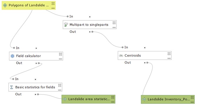
![221](https://user-images.githubusercontent.com/8848123/103148884-91ee6e80-4775-11eb-927b-8376a3255855.jpg)
### 1-1 “00. Extract Study area (Main basins)”
![222](https://user-images.githubusercontent.com/8848123/103148898-c2cea380-4775-11eb-954b-a5c301743c2b.jpg)
### 1-2 “1.a GU Extract Slope values for original inventory”
![2221](https://user-images.githubusercontent.com/8848123/103148965-5bfdba00-4776-11eb-8dd6-ef20b9ae8cb7.jpg)
### 1-3 “1.b GU Extracted Slope values for original inventory statistics”
![223](https://user-images.githubusercontent.com/8848123/103148916-e396f900-4775-11eb-88b9-4aa66cc07b9a.jpg)
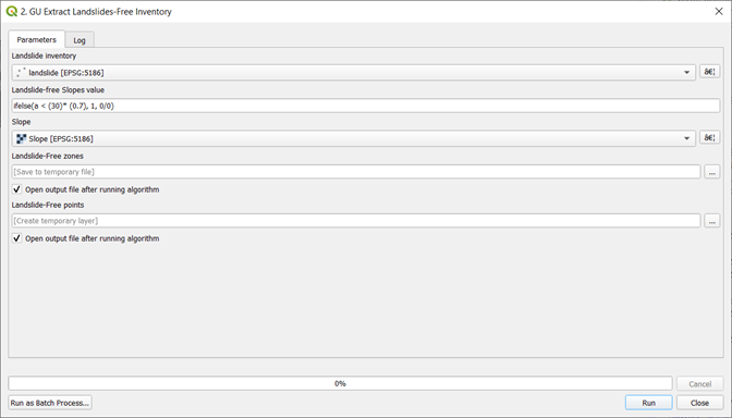
### 1-4 “2. GU Extract Landslides-free inventory”
![224](https://user-images.githubusercontent.com/8848123/103148923-f6113280-4775-11eb-8e35-dc9421e23d57.jpg)
### 1-5 “3.a. GU Extract Training and Testing samples”
![225](https://user-images.githubusercontent.com/8848123/103149126-b0556980-4777-11eb-82f3-969ba14e2dc9.jpg)
### 1-6 “3.b. GU Extract conditioning factors values”
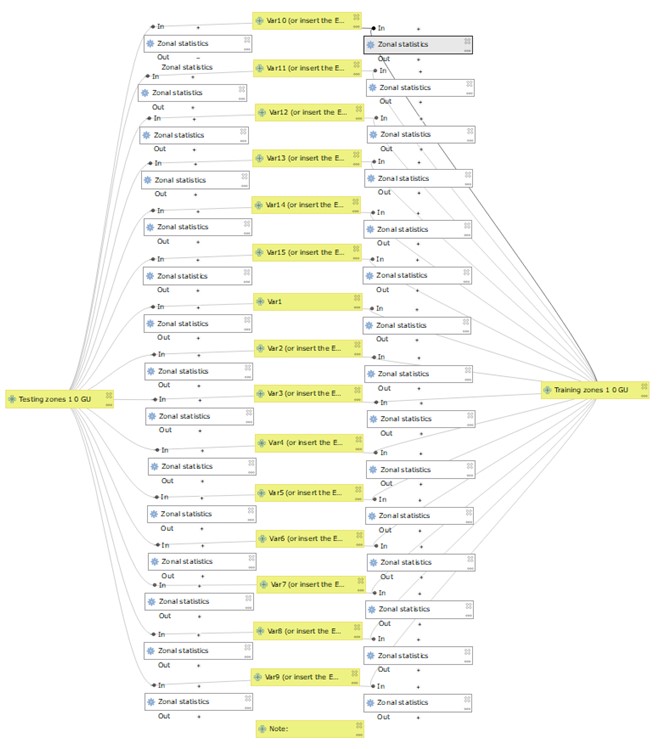
![226](https://user-images.githubusercontent.com/8848123/103149139-d1b65580-4777-11eb-90bd-161c9c9a8997.jpg)
-------------------------------------------------------------------------------------------------------------------
## 2-SLOPE UNIT (SU)
### 2-1 “0. Extract Study area (Main basins)”
The tool is like the one mentioned earlier with GU extraction process.
![331](https://user-images.githubusercontent.com/8848123/103149204-7b95e200-4778-11eb-8357-ab305904b077.jpg)
### 2-2 “1. SU Landslides extraction”
![332](https://user-images.githubusercontent.com/8848123/103149205-7d5fa580-4778-11eb-9796-2a0a51fbb46f.jpg)
### 2-3 “2.a. SU Extract Slope values for original inventory”
![333](https://user-images.githubusercontent.com/8848123/103149209-7f296900-4778-11eb-95b3-adf0a2573143.jpg)
### 2-4 “2.b. SU Extracted Slope values for original inventory statistics”
![2221](https://user-images.githubusercontent.com/8848123/103148965-5bfdba00-4776-11eb-8dd6-ef20b9ae8cb7.jpg)
![223](https://user-images.githubusercontent.com/8848123/103148916-e396f900-4775-11eb-88b9-4aa66cc07b9a.jpg)
### 2-5 “3. SU Extract Landslides-free inventory”
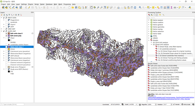
![334](https://user-images.githubusercontent.com/8848123/103149341-974db800-4779-11eb-8af7-a930156f6f5a.PNG)
### 2-6 “4.a. SU Extract Training and Testing samples”
![335](https://user-images.githubusercontent.com/8848123/103149293-345c2100-4779-11eb-8f04-781932a9be66.PNG)
### 2-7 “4.b. SU Extract conditioning factors values”
![226](https://user-images.githubusercontent.com/8848123/103149139-d1b65580-4777-11eb-90bd-161c9c9a8997.jpg)
----------------------------------------------------------------------------------------------------
## GU and SU extraction Tools pack :Case study of landslide inventory
## 1- GRID UNIT tool pack
![1](https://user-images.githubusercontent.com/8848123/103150558-6627b480-4786-11eb-95ca-623f4e51bd02.png)
![2](https://user-images.githubusercontent.com/8848123/103150559-66c04b00-4786-11eb-9d3f-8c1208c0975d.png)
![3](https://user-images.githubusercontent.com/8848123/103150560-6758e180-4786-11eb-8604-ad6ac3fa4da8.png)
![4](https://user-images.githubusercontent.com/8848123/103150563-6758e180-4786-11eb-8268-96bb408c43e9.png)
![5](https://user-images.githubusercontent.com/8848123/103150564-67f17800-4786-11eb-91a4-cee5bb1d1f4c.png)
![6](https://user-images.githubusercontent.com/8848123/103150565-688a0e80-4786-11eb-89ea-df7fe0b5925d.png)
![7](https://user-images.githubusercontent.com/8848123/103150566-6922a500-4786-11eb-9cc8-04fc29f24320.png)
![8](https://user-images.githubusercontent.com/8848123/103150567-6922a500-4786-11eb-9d53-59c63ddb9d88.png)
![9](https://user-images.githubusercontent.com/8848123/103150568-69bb3b80-4786-11eb-8880-fa108d1b262c.png)
![10](https://user-images.githubusercontent.com/8848123/103150569-69bb3b80-4786-11eb-97e7-81e34d31a7ee.png)
![11](https://user-images.githubusercontent.com/8848123/103150570-6a53d200-4786-11eb-82db-8f055e27f2b5.png)
![12](https://user-images.githubusercontent.com/8848123/103150571-6aec6880-4786-11eb-85e8-21f6d3e99955.png)
![13](https://user-images.githubusercontent.com/8848123/103150572-6aec6880-4786-11eb-945b-63819912bf8b.png)
![14](https://user-images.githubusercontent.com/8848123/103150552-62942d80-4786-11eb-97ee-ffc4fe45115e.png)
![15](https://user-images.githubusercontent.com/8848123/103150553-63c55a80-4786-11eb-8087-06f819b70580.png)
![16](https://user-images.githubusercontent.com/8848123/103150554-645df100-4786-11eb-87fe-f007b609b1d0.png)
![17](https://user-images.githubusercontent.com/8848123/103150556-658f1e00-4786-11eb-9ed9-0e37da6fd878.png)
![18](https://user-images.githubusercontent.com/8848123/103150591-a38c4200-4786-11eb-800b-db14f88db5dc.png)
## 2- SLOPE UNIT tool pack
We will start over the process with extraction of study area and data entry of landslide locations and DEM raster only.
![19](https://user-images.githubusercontent.com/8848123/103150645-3cbb5880-4787-11eb-9ab1-ef428a4c414f.png)
![20](https://user-images.githubusercontent.com/8848123/103150646-3cbb5880-4787-11eb-8cc2-ebd04984f200.png)
![21](https://user-images.githubusercontent.com/8848123/103150647-3d53ef00-4787-11eb-8503-9e3e5ad04156.png)
![22](https://user-images.githubusercontent.com/8848123/103150649-3f1db280-4787-11eb-8815-3ea8ca454be7.png)
![23](https://user-images.githubusercontent.com/8848123/103150650-404edf80-4787-11eb-88fa-c23be160a5c4.png)
![24](https://user-images.githubusercontent.com/8848123/103150651-40e77600-4787-11eb-83af-bf4087718260.png)
![25](https://user-images.githubusercontent.com/8848123/103150652-40e77600-4787-11eb-8733-930bb29e33c1.png)
![26](https://user-images.githubusercontent.com/8848123/103150653-41800c80-4787-11eb-9915-7e5fd5ba012c.png)
![27](https://user-images.githubusercontent.com/8848123/103150654-4218a300-4787-11eb-9516-3090d9c019dc.png)
![28](https://user-images.githubusercontent.com/8848123/103150657-4349d000-4787-11eb-9b99-a2dfc62819b9.png)
![29](https://user-images.githubusercontent.com/8848123/103150660-43e26680-4787-11eb-93d8-7606150655b9.png)
![30](https://user-images.githubusercontent.com/8848123/103150662-447afd00-4787-11eb-96e3-545ae7d6f760.png)
![31](https://user-images.githubusercontent.com/8848123/103150663-45139380-4787-11eb-933a-d6096e805bfb.png)
![32](https://user-images.githubusercontent.com/8848123/103150664-45ac2a00-4787-11eb-8bbc-da439c8cde66.png)
![33](https://user-images.githubusercontent.com/8848123/103150644-3b8a2b80-4787-11eb-8d8a-1e6d6706c753.png)
![results](https://user-images.githubusercontent.com/8848123/103150665-45ac2a00-4787-11eb-908a-04b6d14b8025.jpg)